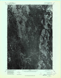
1975 Map of Stacyville SE
USGS Topo · Published 1980About this map
Stacyville appears in the northeast corner of this orthophotoquad, which covers a heavily forested section of Penobscot County in the mid-1970s. This specific type of survey combines the visual accuracy of aerial photography with the geometric precision of a topographic map, providing a raw look at the timberlands and wetlands of the region. The landscape is defined by the winding paths of Mud Brook and Hay Brook, which meander through dense vegetation and boggy lowlands. The sharp contrast between the geometric patterns of agricultural clearings near the town and the undisturbed forest floor highlights the localized nature of settlement in this part of Maine. Unlike a traditional line-map, this imagery reveals the actual density of the canopy and the subtle variations in the terrain during the autumn season.
Find a feature on this map
3 named features on this map. Tap any name to fly to it.
Don’t see what you’re looking for? This feature index may not catch every label — zoom into the map to look around manually.
Map Details
Editions of this 1975 Stacyville SE Map
This is the sole edition of this map. No revisions or reprints were ever made.
Other maps of this area

1940 · Sherman
USGS Topo · 1:62,500

1940 · Mattawamkeag
USGS Topo · 1:62,500

1942 · Mattawamkeag
USGS Topo · 1:62,500

1942 · Sherman
USGS Topo · 1:62,500

1951 · Millinocket
USGS Topo · 1:62,500

1953 · Stacyville
USGS Topo · 1:62,500

1954 · Millinocket
USGS Topo · 1:250,000

1958 · Millinocket
USGS Topo · 1:250,000

1960 · Millinocket
USGS Topo · 1:250,000
1975 · Mattawamkeag NW
USGS Topo · 1:24,000
Featured Places
- Stacyville, ME
- Hay Brook, Soldiertown Township
- T3 R7 WELS, ME
- Soldiertown Township, ME
- Grindstone Township, ME