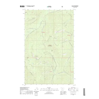
2020 Map of Stahl Peak
USGS Topo · Published 2020About this map
The Whitefish Range and Galton Range dominate this corner of the Kootenai National Forest, where high-elevation landmarks like Stahl Peak and Mt Gibraltar overlook a complex system of drainage and winter recreation routes. The landscape is defined by the convergence of several major watercourses, including the Wigwam River, Grave Creek, and Stahl Creek. Notable for backcountry travelers, the Pacific NW National Scenic Trail traverses the high ridges, while a network of specialized winter routes such as the Grave Creek Snowmobile trail and the Grave Creek Snowmobile Clarence path serve the remote terrain. In the northwest, the Ten Lakes Basin highlights a unique protected area near Therriault Pass, illustrating the modern management of this wilderness for both conservation and seasonal access.
Find a feature on this map
53 named features on this map. Tap any name to fly to it.
Don’t see what you’re looking for? This feature index may not catch every label — zoom into the map to look around manually.
Map Details
Editions of this 2020 Stahl Peak Map
This is the sole edition of this map. No revisions or reprints were ever made.
Other maps of this area

1913 · Stryker
USGS Topo · 1:125,000

1916 · Stryker
USGS Topo · 1:125,000

1957 · Kalispell
USGS Topo · 1:250,000

1960 · Kalispell
USGS Topo · 1:250,000

1961 · Kalispell
USGS Topo · 1:250,000

1963 · Mount Marston
USGS Topo · 1:24,000

1963 · Ksanka Peak
USGS Topo · 1:24,000

1963 · Stahl Peak
USGS Topo · 1:24,000
1963 · Fortine
USGS Topo · 1:24,000
1966 · Mount Thompson-Seton
USGS Topo · 1:24,000