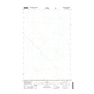
2014 Map of Stahl Peak OE N
USGS Topo · Published 2014About this map
The Wigwam River defines the drainage pattern of this high-latitude region just north of the Canada border. Flowing through the southeastern corner of British Columbia, the river is joined by several significant tributaries, including Desolation Cr and Rabbit Cr. This 2014 survey captures a landscape dominated by natural watercourses and the international boundary line, with Weasel Cr visible in the southernmost reaches. The map provides a clear look at the undeveloped drainage systems in the area north of the United States border, showing how these mountain streams converge as they move through the terrain toward the Koocanusa region.
Find a feature on this map
5 named features on this map. Tap any name to fly to it.
Don’t see what you’re looking for? This feature index may not catch every label — zoom into the map to look around manually.
Map Details
Editions of this 2014 Stahl Peak OE N Map
This is the sole edition of this map. No revisions or reprints were ever made.
Other maps of this area

1913 · Stryker
USGS Topo · 1:125,000

1916 · Stryker
USGS Topo · 1:125,000

1957 · Kalispell
USGS Topo · 1:250,000

1960 · Kalispell
USGS Topo · 1:250,000

1961 · Kalispell
USGS Topo · 1:250,000

1963 · Ksanka Peak
USGS Topo · 1:24,000

1963 · Stahl Peak
USGS Topo · 1:24,000
1966 · Tuchuck Mountain
USGS Topo · 1:24,000
1981 · Whitefish Range
USGS Topo · 1:100,000
1994 · Tuchuck Mountain
USGS Topo · 1:24,000