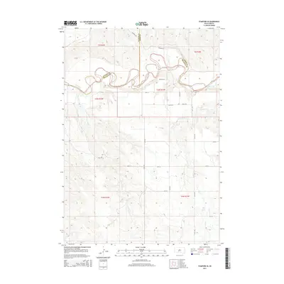
2015 Map of Stamford SE
USGS Topo · Published 2015About this map
The White River winds through the northern portion of this South Dakota landscape, creating a complex series of oxbows and sharp bends that define the boundary between Jackson, Jones, and Mellette Counties. This 2015 survey shows a largely undeveloped expanse of the Swift Bear Segment, where the terrain is marked by significant features like Rocky Point and several intermittent drainages. Water sources are critical in this environment, evidenced by the presence of White Horse Springs in the southeastern quadrant and the network of creeks including Runs Close Cr, Yukmi Cr, and Laryie Cr. The local infrastructure follows a strictly rectilinear grid of section lines, with routes such as Stamford Rd, W Redfish Rd, and 248th St providing access to this section of the Great Plains. A more organic path, the River Trl, follows the northern bank of the river, suggesting traditional movement patterns along the waterway.
Find a feature on this map
29 named features on this map. Tap any name to fly to it.
Don’t see what you’re looking for? This feature index may not catch every label — zoom into the map to look around manually.
Map Details
Editions of this 2015 Stamford SE Map
This is the sole edition of this map. No revisions or reprints were ever made.
Other maps of this area

1951 · Stamford SW
USGS Topo · 1:24,000

1951 · Stamford SE
USGS Topo · 1:24,000

1951 · Cedar Butte NW
USGS Topo · 1:24,000

1951 · Cedar Butte NE
USGS Topo · 1:24,000

1951 · Okaton SW
USGS Topo · 1:24,000

1951 · Murdo 3 NW
USGS Topo · 1:24,000

1955 · Martin
USGS Topo · 1:250,000

1958 · Martin
USGS Topo · 1:250,000

1972 · Okaton
USGS Topo · 1:24,000

1972 · Stamford NW
USGS Topo · 1:24,000