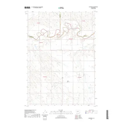
2017 Map of Stamford SE
USGS Topo · Published 2017About this map
The White River carves a complex, winding path through the northern portion of this South Dakota landscape, defining the jagged border between Jackson Co, Jones Co, and Mellette Co. This rural terrain is characterized by a dense network of intermittent drainages, including Runs Close Cr, Yukmi Cr, and Laurie Cr, which feed into the main river valley. Farther south, the upland plains are marked by significant local landmarks such as White Horse Springs. For those researching regional genealogy or parish history, the presence of the Saint Paul German Lutheran Cem and the Good Road Cem provides specific points of interest. The map's layout reflects the traditional Public Land Survey System, with township and range lines like t45n r31w anchoring the legal geography of the ranching and agricultural lands south of the river.
Find a feature on this map
18 named features on this map. Tap any name to fly to it.
Don’t see what you’re looking for? This feature index may not catch every label — zoom into the map to look around manually.
Map Details
Editions of this 2017 Stamford SE Map
This is the sole edition of this map. No revisions or reprints were ever made.
Other maps of this area

1951 · Stamford SW
USGS Topo · 1:24,000

1951 · Stamford SE
USGS Topo · 1:24,000

1951 · Cedar Butte NW
USGS Topo · 1:24,000

1951 · Cedar Butte NE
USGS Topo · 1:24,000

1951 · Okaton SW
USGS Topo · 1:24,000

1951 · Murdo 3 NW
USGS Topo · 1:24,000

1955 · Martin
USGS Topo · 1:250,000

1958 · Martin
USGS Topo · 1:250,000

1972 · Okaton
USGS Topo · 1:24,000

1972 · Stamford NW
USGS Topo · 1:24,000