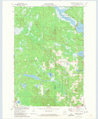
1971 Map of Stanberry East
USGS Topo · Published 1973About this map
The Soo Line railroad cuts through the southwestern corner of this landscape, connecting the small settlement of Stanberry to the wider region during the early 1970s. This area of Washburn and Sawyer Counties is defined by an intricate network of water and wetlands, where Chippanazie Creek flows through the center of the map toward the Kissick Swamp. To the north, the Totagatic River Flowage and the expansive Nelson Lake dominate the terrain, supported by a State Wildlife Management Area that underscores the region's focus on conservation and natural resource management. Local infrastructure is visible through landmarks such as the State Nursery and a Radio Tower (WRLS-FM) near the Hayward township line. Genealogists and local historians can locate the Greenwood Cemetery in the southeast, while the presence of a Gravel Pit and several smaller lakes like Stanberry Lake and Smith Lake illustrate the local geological and industrial character of the Northwoods.
Find a feature on this map
28 named features on this map. Tap any name to fly to it.
Don’t see what you’re looking for? This feature index may not catch every label — zoom into the map to look around manually.
Map Details
Editions of this 1971 Stanberry East Map
This is the sole edition of this map. No revisions or reprints were ever made.
Other maps of this area

1944 · Couderay
USGS Topo · 1:48,000

1944 · Hayward
USGS Topo · 1:48,000

1947 · Chittamo
USGS Topo · 1:48,000

1948 · Couderay
USGS Topo · 1:48,000

1948 · Stone Lake
USGS Topo · 1:48,000

1949 · Chittamo
USGS Topo · 1:48,000

1950 · Stone Lake
USGS Topo · 1:48,000

1953 · Ashland
USGS Topo · 1:250,000

1953 · Rice Lake
USGS Topo · 1:250,000

1958 · Ashland
USGS Topo · 1:250,000