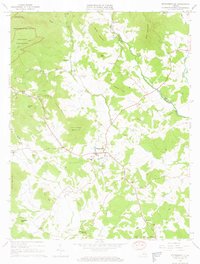
1964 Map of Standardsville
USGS Topo · Published 1966About this map
Stanardsville serves as the focal point of this Greene County landscape during the mid-1960s, situated at the base of the Blue Ridge foothills. The town's layout includes Monroe High Sch and Stanardsville Sch, alongside critical local infrastructure such as a Sewage Disposal plant and a Radio Tower. The survey illustrates a rural society organized around small crossroads like Kinderhook, Amicus, and Brills Shop, where local life centered on community anchors like First Bible Ch and Mountain View Ch.
Find a feature on this map
61 named features on this map. Tap any name to fly to it.
Don’t see what you’re looking for? This feature index may not catch every label — zoom into the map to look around manually.
Map Details
Editions of this 1964 Standardsville Map
4 editions found
Other maps of this area

1892 · Gordonsville
USGS Topo · 1:125,000

1892 · Harrisonburg
USGS Topo · 1:125,000

1930 · Madison
USGS Topo · 1:48,000

1931 · University
USGS Topo · 1:62,500

1933 · Madison
USGS Topo · 1:62,500

1935 · Charlottesville
USGS Topo · 1:62,500

1935 · University
USGS Topo · 1:62,500

1937 · Elkton
USGS Topo · 1:62,500

1939 · Charlottesville
USGS Topo · 1:62,500

1949 · Charlottesville
USGS Topo · 1:250,000