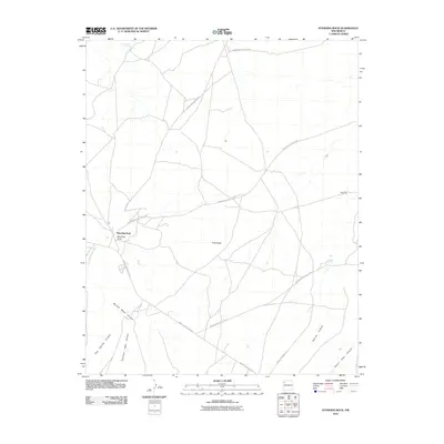
2010 Map of Standing Rock
USGS Topo · Published 2010About this map
Standing Rock serves as the primary focal point of this Eastern Navajo Agency landscape, situated where the high desert terrain begins to fold into complex geological formations. The area is defined by a network of traditional travel corridors, most notably Navajo Service Route 9 and Indian Service Route 7021, which connect the settlement to the surrounding mesa and canyon country. To the south and east, the topography becomes deeply incised by drainage systems such as Burned Water Canyon, Narrow Canyon, and the prominent Dalton Pass Canyon, illustrating the erosional forces that have shaped this region. Distinctive landmarks like Twin Peaks and Dry Hill provide essential orientation points across the open range, while Rough Rock Spring in the northern reaches marks a vital water source in an otherwise arid environment.
Find a feature on this map
16 named features on this map. Tap any name to fly to it.
Don’t see what you’re looking for? This feature index may not catch every label — zoom into the map to look around manually.
Map Details
Editions of this 2010 Standing Rock Map
This is the sole edition of this map. No revisions or reprints were ever made.
Other maps of this area

1886 · Wingate
USGS Topo · 1:250,000

1892 · Wingate
USGS Topo · 1:250,000

1954 · Gallup
USGS Topo · 1:250,000

1958 · Gallup
USGS Topo · 1:250,000

1959 · Gallup
USGS Topo · 1:250,000

1962 · Gallup
USGS Topo · 1:250,000
1963 · Crownpoint
USGS Topo · 1:24,000
1963 · Dalton Pass
USGS Topo · 1:24,000
1963 · Oak Spring
USGS Topo · 1:24,000

1967 · Gallup
USGS Topo · 1:250,000
Featured Places
- Eastern Navajo Agency, NM
- Standing Rock, Eastern Navajo Agency
- McKinley County, NM
- United States
- New Mexico