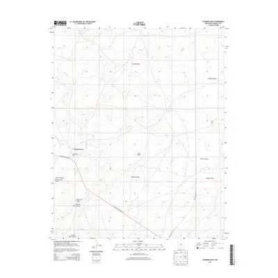
2013 Map of Standing Rock
USGS Topo · Published 2013About this map
Standing Rock serves as a primary settlement hub in this part of the Eastern Navajo Agency, situated along the corridor of Navajo Service Route 9. The high desert landscape is defined by a series of prominent landforms and drainage systems, including the notable Twin Peaks and Dry Hill to the north. Seasonal water sources and geological features are clearly documented, from the vital Rough Rock Spring in the northwestern corner to the winding Standing Rock Wash. The southern half of the quadrangle is deeply incised by a network of drainages such as Pinetree Canyon, Burned Water Canyon, and Running Edge Canyon, which reflect the complex erosion patterns of the McKinley County plateau. This 2013 survey provides a clear view of the intersection between established road networks like Maholland Well Rd and the traditional place names that define this community.
Find a feature on this map
16 named features on this map. Tap any name to fly to it.
Don’t see what you’re looking for? This feature index may not catch every label — zoom into the map to look around manually.
Map Details
Editions of this 2013 Standing Rock Map
This is the sole edition of this map. No revisions or reprints were ever made.
Other maps of this area

1886 · Wingate
USGS Topo · 1:250,000

1892 · Wingate
USGS Topo · 1:250,000

1954 · Gallup
USGS Topo · 1:250,000

1958 · Gallup
USGS Topo · 1:250,000

1959 · Gallup
USGS Topo · 1:250,000

1962 · Gallup
USGS Topo · 1:250,000
1963 · Crownpoint
USGS Topo · 1:24,000
1963 · Dalton Pass
USGS Topo · 1:24,000
1963 · Oak Spring
USGS Topo · 1:24,000

1967 · Gallup
USGS Topo · 1:250,000
Featured Places
- Eastern Navajo Agency, NM
- Standing Rock, Eastern Navajo Agency
- McKinley County, NM
- United States
- New Mexico