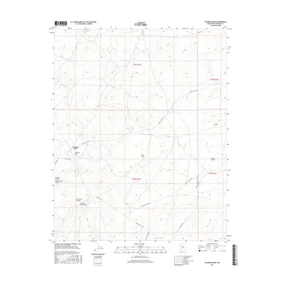
2017 Map of Standing Rock
USGS Topo · Published 2017About this map
Standing Rock serves as the central settlement point in this high-desert landscape of McKinley County, where traditional land management and Bureau of Indian Affairs infrastructure intersect. The terrain is defined by a series of deep drainage systems including Pinetree Canyon, Burned Water Canyon, and Dog Spring Canyon, which carve through the sandstone formations typical of the Eastern Navajo Agency. Significant elevation changes are marked by Twin Peaks and Dry Hill, while seasonal water sources like Rough Rock Spring and Mulholland Well indicate the critical points for livestock and human habitation in this arid environment. The map details an extensive network of service routes, such as Navajo Svc Rte 9 and Indian Svc Rte 7021, which facilitate travel between remote homesteads and the community center.
Find a feature on this map
22 named features on this map. Tap any name to fly to it.
Don’t see what you’re looking for? This feature index may not catch every label — zoom into the map to look around manually.
Map Details
Editions of this 2017 Standing Rock Map
This is the sole edition of this map. No revisions or reprints were ever made.
Other maps of this area

1886 · Wingate
USGS Topo · 1:250,000

1892 · Wingate
USGS Topo · 1:250,000

1954 · Gallup
USGS Topo · 1:250,000

1958 · Gallup
USGS Topo · 1:250,000

1959 · Gallup
USGS Topo · 1:250,000

1962 · Gallup
USGS Topo · 1:250,000
1963 · Crownpoint
USGS Topo · 1:24,000
1963 · Dalton Pass
USGS Topo · 1:24,000
1963 · Oak Spring
USGS Topo · 1:24,000

1967 · Gallup
USGS Topo · 1:250,000
Featured Places
- Eastern Navajo Agency, NM
- Standing Rock, Eastern Navajo Agency
- McKinley County, NM
- United States
- New Mexico