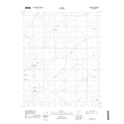
2020 Map of Standing Rock
USGS Topo · Published 2020About this map
Standing Rock serves as the central focal point of this high-desert landscape in the Eastern Navajo Agency. The terrain is defined by a series of deep drainage systems, most notably Standing Rock Wash and several prominent canyons including Burned Water Canyon, Pinetree Canyon, and Dog Spring Canyon. The topographical character is punctuated by the Twin Peaks and Dry Hill, while Rough Rock Spring provides a named water source in the northern reaches. The settlement pattern is sparse, connected by a network of service routes and local roads such as Navajo Svc Rte 9 and Indian Svc Rte 7021. To the south, the land rises toward the Dalton Pass Canyon, showcasing the traditional importance of these natural corridors for movement through the region.
Find a feature on this map
24 named features on this map. Tap any name to fly to it.
Don’t see what you’re looking for? This feature index may not catch every label — zoom into the map to look around manually.
Map Details
Editions of this 2020 Standing Rock Map
This is the sole edition of this map. No revisions or reprints were ever made.
Other maps of this area

1886 · Wingate
USGS Topo · 1:250,000

1892 · Wingate
USGS Topo · 1:250,000

1954 · Gallup
USGS Topo · 1:250,000

1958 · Gallup
USGS Topo · 1:250,000

1959 · Gallup
USGS Topo · 1:250,000

1962 · Gallup
USGS Topo · 1:250,000
1963 · Crownpoint
USGS Topo · 1:24,000
1963 · Dalton Pass
USGS Topo · 1:24,000
1963 · Oak Spring
USGS Topo · 1:24,000

1967 · Gallup
USGS Topo · 1:250,000
Featured Places
- Eastern Navajo Agency, NM
- Standing Rock, Eastern Navajo Agency
- McKinley County, NM
- United States
- New Mexico