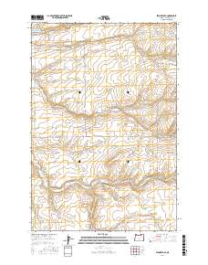
2017 Map of Stanfield SE
USGS Topo · Published 2017About this map
Cold Springs Reservoir dominates the northwestern corner of this landscape, its waters feeding into the deep incision of Cold Springs Canyon. The surrounding terrain in Umatilla County is defined by a rhythmic succession of drainages and ridges, including the prominent Despain Gulch and Stage Gulch. This 2017 survey reveals an organized grid of rural roads and county routes that trace the section lines of the Public Land Survey System, specifically within townships t5n r30e, t4n r30e, and t3n r30e. Named thoroughfares like Moorehouse Rd and Wells Stn Rd indicate historical transit corridors through this agricultural region, where the land-use patterns are shaped by the natural topography of the high desert plateau and its erosional gullies.
Find a feature on this map
22 named features on this map. Tap any name to fly to it.
Don’t see what you’re looking for? This feature index may not catch every label — zoom into the map to look around manually.
Map Details
Editions of this 2017 Stanfield SE Map
This is the sole edition of this map. No revisions or reprints were ever made.
Other maps of this area

1908 · Umatilla
USGS Topo · 1:125,000

1935 · Pendleton
USGS Topo · 1:125,000

1953 · Pendleton
USGS Topo · 1:250,000

1956 · Pendleton
USGS Topo · 1:250,000

1962 · Hat Rock
USGS Topo · 1:24,000

1962 · Stanfield
USGS Topo · 1:24,000

1962 · Juniper
USGS Topo · 1:24,000

1962 · Stanfield SE
USGS Topo · 1:24,000
1966 · Juniper Canyon
USGS Topo · 1:24,000

1966 · Holdman
USGS Topo · 1:24,000