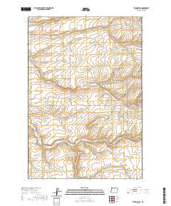
2020 Map of Stanfield SE
USGS Topo · Published 2020About this map
Cold Springs Canyon and Despain Gulch carve through the high plains of Umatilla County, defining a landscape dominated by the deep incisions of seasonal drainage. This 2020 edition provides a clear picture of the modern rural infrastructure, showing a grid of local connectors and county roads that navigate the complex topography. While the upland reaches are primarily characterized by their terrain, the network of routes like Wells Station Rd and Moorehouse Rd reveal the enduring importance of access to these drainage basins. These natural landmarks, including Stage Gulch, have shaped the orientation of rural properties and movement through the region for generations. The map highlights the intersection of public land survey boundaries and the natural contours of the Oregon desert landscape, documenting how local names like Kilgore Rd and Lorenzen Rd are anchored to the physical geography of the gulches and canyons.
Find a feature on this map
21 named features on this map. Tap any name to fly to it.
Don’t see what you’re looking for? This feature index may not catch every label — zoom into the map to look around manually.
Map Details
Editions of this 2020 Stanfield SE Map
This is the sole edition of this map. No revisions or reprints were ever made.
Other maps of this area

1908 · Umatilla
USGS Topo · 1:125,000

1935 · Pendleton
USGS Topo · 1:125,000

1953 · Pendleton
USGS Topo · 1:250,000

1956 · Pendleton
USGS Topo · 1:250,000

1962 · Hat Rock
USGS Topo · 1:24,000

1962 · Stanfield
USGS Topo · 1:24,000

1962 · Juniper
USGS Topo · 1:24,000

1962 · Stanfield SE
USGS Topo · 1:24,000
1966 · Juniper Canyon
USGS Topo · 1:24,000

1966 · Holdman
USGS Topo · 1:24,000