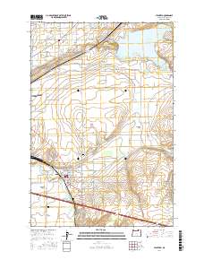
2017 Map of Stanfield
USGS Topo · Published 2017About this map
Stanfield serves as the central hub of this Umatilla County landscape, where a sophisticated network of water management infrastructure supports the local agriculture. The Umatilla River winds through the southern portion of the quadrangle, flanked by the residential clusters of Umatilla Meadows and Echo Meadows. This map documents an intricate system of irrigation, featuring the Hermiston Ditch, Maxwell Canal, and the A-Line Canal, which redirect water from sources like the Walchli Reservoir and the expansive Cold Springs Reservoir to the surrounding fields. For local historians and genealogists, the map identifies several significant burial sites, including Pleasant View Cem, Foster Cem, and Baumgardner Cem. The transition from the irrigated lowlands to the more dissected terrain of Fourmile Gap and Stage Gulch illustrates the varied geography of this Eastern Oregon region.
Find a feature on this map
112 named features on this map. Tap any name to fly to it.
Don’t see what you’re looking for? This feature index may not catch every label — zoom into the map to look around manually.
Map Details
Editions of this 2017 Stanfield Map
This is the sole edition of this map. No revisions or reprints were ever made.
Other maps of this area

1908 · Umatilla
USGS Topo · 1:125,000

1953 · Pendleton
USGS Topo · 1:250,000

1956 · Pendleton
USGS Topo · 1:250,000

1962 · Hat Rock
USGS Topo · 1:24,000

1962 · Stanfield
USGS Topo · 1:24,000

1962 · Hermiston
USGS Topo · 1:24,000

1962 · Juniper
USGS Topo · 1:24,000

1962 · Umatilla
USGS Topo · 1:24,000

1962 · Stanfield SE
USGS Topo · 1:24,000
1968 · Echo
USGS Topo · 1:24,000