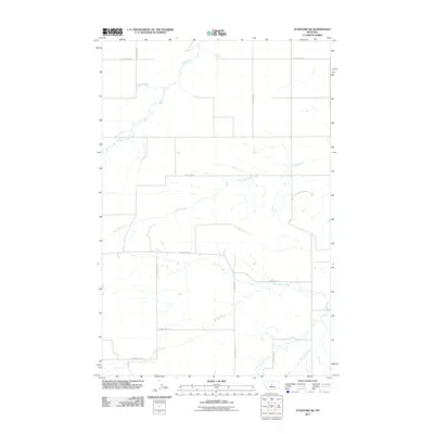
2011 Map of Stanford NE
USGS Topo · Published 2011About this map
Coyote Creek and its various tributaries carve through the central Montana landscape in this 2011 survey of the Stanford NE quadrangle. The area is defined by its extensive drainage network, including the winding paths of Dry Wolf Creek and Willow Creek, which dictate the placement of local thoroughfares like S-207 and County Rd-328. The map documents a predominantly rural infrastructure where transportation relies on a grid-like system of section-line roads, such as County Rd-334 and County Rd-341. Smaller water features like Spring Creek and Spring Branch provide localized geographic context in a region where water sources and topographic contours are the primary landmarks for navigation and land management.
Find a feature on this map
16 named features on this map. Tap any name to fly to it.
Don’t see what you’re looking for? This feature index may not catch every label — zoom into the map to look around manually.
Map Details
Editions of this 2011 Stanford NE Map
This is the sole edition of this map. No revisions or reprints were ever made.
Other maps of this area

1890 · Fort Benton
USGS Topo · 1:250,000

1892 · Fort Benton
USGS Topo · 1:250,000

1897 · Fort Benton
USGS Topo · 1:250,000

1954 · Great Falls
USGS Topo · 1:250,000

1954 · Lewistown
USGS Topo · 1:250,000

1957 · Great Falls
USGS Topo · 1:250,000

1959 · Lewistown
USGS Topo · 1:250,000
1970 · Moccasin
USGS Topo · 1:24,000
1970 · Big Spring
USGS Topo · 1:24,000
1978 · Stanford NE
USGS Topo · 1:24,000