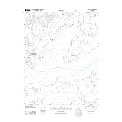
2012 Map of Stanislaus
USGS Topo · Published 2012About this map
Hathaway Pines and Avery serve as the primary residential hubs in this portion of the Sierra Nevada foothills, where the landscape is defined by the deep canyons of the N Fork Stanislaus River and the Middle Fork Stanislaus River. This 2012 survey illustrates the extensive water management infrastructure vital to the region, featuring the Stanislaus Tunnel and the Utica Ditch, along with several high-altitude reservoirs like Hunter Reservoir and Pinebrook Reservoir. The mountain geography is punctuated by specific summits such as Doud Hill and Cone Hill, while the Calaveras District Ranger Office and Mc Cormick Lookout highlight the area's ongoing importance for forest management and fire observation. Recreational and residential developments like Fly-In Acres and Ebbetts Pass Highlands show the modern character of these timbered ridges above Griswold Cr and Beaver Cr.
Find a feature on this map
51 named features on this map. Tap any name to fly to it.
Don’t see what you’re looking for? This feature index may not catch every label — zoom into the map to look around manually.
Map Details
Editions of this 2012 Stanislaus Map
This is the sole edition of this map. No revisions or reprints were ever made.
Other maps of this area

1891 · Big Trees
USGS Topo · 1:125,000

1894 · Big Trees
USGS Topo · 1:125,000

1897 · Big Trees
USGS Topo · 1:125,000

1901 · Big Trees
USGS Topo · 1:125,000

1947 · Sacramento
USGS Topo · 1:250,000

1948 · Sacramento
USGS Topo · 1:250,000

1948 · Columbia
USGS Topo · 1:62,500
1948 · Columbia SE
USGS Topo · 1:24,000
1948 · Columbia
USGS Topo · 1:24,000
1948 · Murphys
USGS Topo · 1:24,000