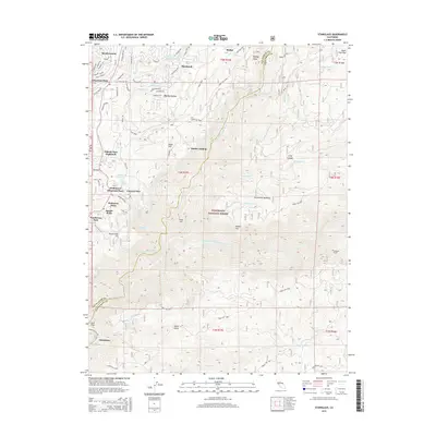
2015 Map of Stanislaus
USGS Topo · Published 2015About this map
Stanislaus National Forest anchors this Sierra Nevada landscape, where the N Fork Stanislaus River and Middle Fork Stanislaus River carve through deep canyons. The settlement pattern is concentrated in the western reaches, with residential clusters like Ebbetts Pass Highlands, Lakemont Pines, and Hathaway Pines showing the area's development. Local infrastructure for water management is evident through the winding path of the Utica Ditch and several impoundments including Hunter Reservoir and Fly-in Acres Reservoir. To the east, the terrain becomes more dominated by the timbered slopes of the national forest, marked by landmarks such as McCormick Meadows and McKay. The technical footprint of the regional water and power system is represented by the Stanislaus Tunnel near the confluence of Griswold Cr and the main river, while the tiny settlement of Stanislaus sits near the southern boundary at Clark Flat.
Find a feature on this map
56 named features on this map. Tap any name to fly to it.
Don’t see what you’re looking for? This feature index may not catch every label — zoom into the map to look around manually.
Map Details
Editions of this 2015 Stanislaus Map
This is the sole edition of this map. No revisions or reprints were ever made.
Other maps of this area

1891 · Big Trees
USGS Topo · 1:125,000

1894 · Big Trees
USGS Topo · 1:125,000

1897 · Big Trees
USGS Topo · 1:125,000

1901 · Big Trees
USGS Topo · 1:125,000

1947 · Sacramento
USGS Topo · 1:250,000

1948 · Sacramento
USGS Topo · 1:250,000

1948 · Columbia
USGS Topo · 1:62,500
1948 · Columbia SE
USGS Topo · 1:24,000
1948 · Columbia
USGS Topo · 1:24,000
1948 · Murphys
USGS Topo · 1:24,000