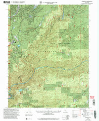
2001 Map of Stanislaus
USGS Topo · Published 2004About this map
The Middle Fork Stanislaus River carves through this Sierra Nevada landscape, marking the boundary between Calaveras and Tuolumne counties. This 2001 revision illustrates a complex mosaic of protected lands and residential clusters, where the Tuolumne State Game Refuge and Stanislaus National Forest meet private developments. Settlement patterns are concentrated along the western edge near Avery and Hathaway Pines, featuring facilities like the Arnold CDF Fire Sta and St Clares Episcopal Ch. The terrain is characterized by high meadows and strategic lookouts such as Rattlesnake Hill and Sunset Point. Water management is prominent throughout the quadrangle, evidenced by a network of reservoirs including McKays Reservoir, Beaver Creek Reservoir, and the Forebay, which support the region's utilities. Industry and infrastructure are represented by the Candy Rock Quarry and several forest service facilities, including the Hathaway Pines Work Station.
Find a feature on this map
44 named features on this map. Tap any name to fly to it.
Don’t see what you’re looking for? This feature index may not catch every label — zoom into the map to look around manually.
Map Details
Editions of this 2001 Stanislaus Map
This is the sole edition of this map. No revisions or reprints were ever made.
Other maps of this area

1891 · Big Trees
USGS Topo · 1:125,000

1894 · Big Trees
USGS Topo · 1:125,000

1897 · Big Trees
USGS Topo · 1:125,000

1901 · Big Trees
USGS Topo · 1:125,000

1947 · Sacramento
USGS Topo · 1:250,000

1948 · Sacramento
USGS Topo · 1:250,000

1948 · Columbia
USGS Topo · 1:62,500
1948 · Columbia SE
USGS Topo · 1:24,000
1948 · Columbia
USGS Topo · 1:24,000
1948 · Murphys
USGS Topo · 1:24,000