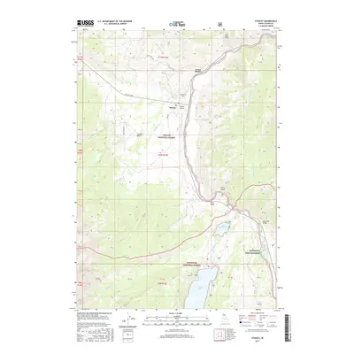
2017 Map of Stanley
USGS Topo · Published 2017About this map
The confluence of Valley Cr and the Salmon River serves as the focal point for the neighboring settlements of Stanley and Lower Stanley. This high-altitude basin, where the Challis National Forest meets the Sawtooth National Forest, is defined by its glacial hydrology and modern infrastructure. Local history is anchored at the Stanley Cem and the Stanley Airport, which occupy a relatively flat terrace above the river. To the south, the landscape transitions into the Sawtooth Valley, where the Sawtooth Fish Hatchery stands near the outlet of Little Redfish Lake. The drainage patterns of Fishhook Cr and Redfish Lake Cr illustrate the complex water network feeding into the larger Redfish Lake, while Sheep Bridge provides a tangible crossing point for researchers tracing early mountain transit routes.
Find a feature on this map
34 named features on this map. Tap any name to fly to it.
Don’t see what you’re looking for? This feature index may not catch every label — zoom into the map to look around manually.
Map Details
Editions of this 2017 Stanley Map
This is the sole edition of this map. No revisions or reprints were ever made.
Other maps of this area

1891 · Bear Valley
USGS Topo · 1:125,000

1893 · Bear Valley
USGS Topo · 1:125,000

1919 · Custer
USGS Topo · 1:125,000

1922 · Custer
USGS Topo · 1:125,000

1957 · Challis
USGS Topo · 1:250,000

1960 · Challis
USGS Topo · 1:250,000

1963 · Challis
USGS Topo · 1:250,000

1963 · Mt Cramer
USGS Topo · 1:24,000

1963 · Stanley
USGS Topo · 1:24,000

1963 · Basin Butte
USGS Topo · 1:24,000