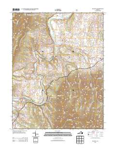
2013 Map of Stanley
USGS Topo · Published 2013About this map
The S Fork Shenandoah River carves a sweeping path through this Page County landscape, dictating the placement of early riverfront settlements and agricultural corridors. Communities such as Alma, Honeyville, and Newport are established along the valley floor, while the terrain climbs sharply to the east into the high ridges of Roundhead Mountain and Smith Mountain. The presence of Grove Hill Landing underscores the importance of the river as a historical artery for transport and commerce before modern road networks dominated. To the south, the topography becomes increasingly complex, marked by locally named landmarks like Devils Tanyard and The Pinnacle. The transition from the alluvial plains of the Shenandoah to the steep hollows such as Stark Hollow and Steam Hollow reflects the traditional Appalachian land use patterns of valley-bottom farming and upland timbering.
Find a feature on this map
144 named features on this map. Tap any name to fly to it.
Don’t see what you’re looking for? This feature index may not catch every label — zoom into the map to look around manually.
Map Details
Editions of this 2013 Stanley Map
This is the sole edition of this map. No revisions or reprints were ever made.
Other maps of this area

1892 · Woodstock
USGS Topo · 1:125,000

1892 · Gordonsville
USGS Topo · 1:125,000

1892 · Harrisonburg
USGS Topo · 1:125,000

1893 · Luray
USGS Topo · 1:125,000

1905 · Luray
USGS Topo · 1:125,000

1929 · Stony Man
USGS Topo · 1:48,000

1930 · Madison
USGS Topo · 1:48,000

1933 · Stony Man
USGS Topo · 1:62,500

1933 · Madison
USGS Topo · 1:62,500

1937 · Elkton
USGS Topo · 1:62,500