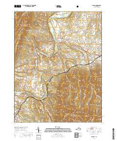
2019 Map of Stanley
USGS Topo · Published 2019About this map
The South Fork Shenandoah River winds through the heart of Page Valley, defining the agricultural and transit corridor between two major mountain ranges. To the west, the George Washington National Forest rises toward First Mtn, while the eastern portion of the map climbs into the heights of Shenandoah National Park, featuring landmarks like The Pinnacle and Dog Slaughter Ridge. The Norfolk Southern railway tracks parallel the river, connecting small settlements like Ingham, Grove Hill, and the town of Shenandoah at the southern edge. Local history is preserved in numerous family and community burial sites, including Saint Pauls Cem and Comer Cem. This landscape shows a distinct pattern of valley floor farming and commerce, notably around the town of Stanley, set against the steep, wooded terrain of the surrounding ridges.
Find a feature on this map
133 named features on this map. Tap any name to fly to it.
Don’t see what you’re looking for? This feature index may not catch every label — zoom into the map to look around manually.
Map Details
Editions of this 2019 Stanley Map
This is the sole edition of this map. No revisions or reprints were ever made.
Other maps of this area

1892 · Woodstock
USGS Topo · 1:125,000

1892 · Gordonsville
USGS Topo · 1:125,000

1892 · Harrisonburg
USGS Topo · 1:125,000

1893 · Luray
USGS Topo · 1:125,000

1905 · Luray
USGS Topo · 1:125,000

1929 · Stony Man
USGS Topo · 1:48,000

1930 · Madison
USGS Topo · 1:48,000

1933 · Stony Man
USGS Topo · 1:62,500

1933 · Madison
USGS Topo · 1:62,500

1937 · Elkton
USGS Topo · 1:62,500