
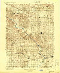
1901 Map of Stanwood
USGS Topo · Published 1901About this map
The Cedar River carves a winding path through the center of this eastern Iowa landscape, serving as a primary geographical anchor between the emerging rail towns and agrarian townships of the late nineteenth century. The county seat of Tipton sits at a crossroads of commerce, surrounded by a dense network of smaller settlements such as Rochester and Cedar Bluff. The map reveals the critical role of steam transportation, with several major lines including the Chicago and Northwestern R.R. and the Chicago Rock Island and Pacific R.R. bisecting the fertile plains. These corridors fostered the growth of towns like West Liberty, Mechanicsville, and Mt. Vernon, which are depicted here in their early development. Beyond the tracks, smaller locales like Lime City, Plato, and Springdale offer a detailed view of the rural community structure before the widespread adoption of modern highways.
Find a feature on this map
84 named features on this map. Tap any name to fly to it.
Don’t see what you’re looking for? This feature index may not catch every label — zoom into the map to look around manually.
Map Details
Editions of this 1901 Stanwood Map
2 editions found
Other maps of this area

1887 · Cedar Rapids
USGS Topo · 1:62,500

1888 · Marion
USGS Topo · 1:62,500

1889 · Tipton
USGS Topo · 1:62,500

1889 · Marion
USGS Topo · 1:62,500

1890 · Durant
USGS Topo · 1:62,500

1890 · Tipton
USGS Topo · 1:62,500

1890 · Anamosa
USGS Topo · 1:62,500

1891 · Monticello
USGS Topo · 1:62,500

1891 · Mechanicsville
USGS Topo · 1:62,500

1891 · Cedar Rapids
USGS Topo · 1:62,500