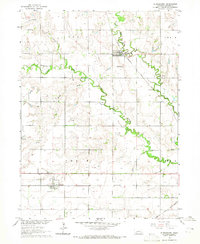
1964 Map of Staplehurst
USGS Topo · Published 1965About this map
Staplehurst and Tamora serve as the primary rail-oriented hubs in this mid-1960s agricultural survey of Seward County. The landscape is defined by the winding course of the Big Blue River and its major tributaries, including Lincoln Creek, Cottonwood Creek, and Brush Creek. The density of rural cemeteries, such as the American Cem, Staplehurst Cem, Immanuel Cem, and Tamora Cem, reflects a deeply rooted settlement pattern established by early farming families. Two major rail corridors, the Chicago Burlington and Quincy and the Chicago and North Western, anchor the local economy. Beyond the towns, the presence of the Zion Sch and a Gravel Pit along the creek banks highlights the essential community infrastructure of the era. A Gaging Station on the river further indicates the ongoing management of the Missouri River Basin watershed.
Find a feature on this map
19 named features on this map. Tap any name to fly to it.
Don’t see what you’re looking for? This feature index may not catch every label — zoom into the map to look around manually.
Map Details
Editions of this 1964 Staplehurst Map
This is the sole edition of this map. No revisions or reprints were ever made.
Other maps of this area

1899 · David City
USGS Topo · 1:125,000

1934 · Seward
USGS Topo · 1:48,000

1934 · Utica
USGS Topo · 1:62,500

1937 · Utica
USGS Topo · 1:62,500

1939 · Seward
USGS Topo · 1:62,500

1955 · Fremont
USGS Topo · 1:250,000

1955 · Lincoln
USGS Topo · 1:250,000

1957 · Fremont
USGS Topo · 1:250,000

1957 · Lincoln
USGS Topo · 1:250,000

1958 · Fremont
USGS Topo · 1:250,000