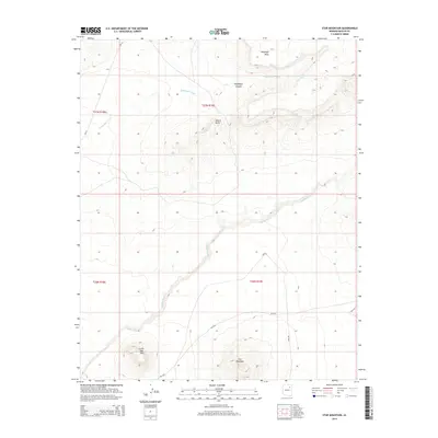
2014 Map of Star Mountain
USGS Topo · Published 2014About this map
Antelope Mesa overlooks a landscape of complex drainage systems and volcanic landforms within Navajo County. The high ground is dominated by the prominent peaks of Star Mountain and Little Star Mtn in the south, while Adams Butte stands as a distinct landmark further north. These elevations contrast with the deep incisions of Talahogan Canyon, where the seasonal flow of Talahogan Wash and the presence of Talahogan Spring suggest critical water sources in an otherwise arid environment.
Find a feature on this map
17 named features on this map. Tap any name to fly to it.
Don’t see what you’re looking for? This feature index may not catch every label — zoom into the map to look around manually.
Map Details
Editions of this 2014 Star Mountain Map
This is the sole edition of this map. No revisions or reprints were ever made.
Other maps of this area

1883 · Tusayan
USGS Topo · 1:250,000

1886 · Tusayan
USGS Topo · 1:250,000

1947 · Flagstaff
USGS Topo · 1:250,000

1954 · Flagstaff
USGS Topo · 1:250,000

1958 · Flagstaff
USGS Topo · 1:250,000

1960 · Flagstaff
USGS Topo · 1:250,000

1962 · Flagstaff
USGS Topo · 1:250,000

1966 · White Cone
USGS Topo · 1:62,500

1966 · Egloffstein Butte
USGS Topo · 1:62,500
1966 · Keams Canyon
USGS Topo · 1:62,500