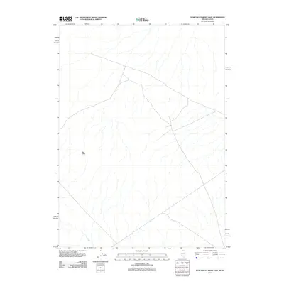
2012 Map of Star Valley Ridge East
USGS Topo · Published 2012About this map
Star Valley Ridge dominates this high-altitude landscape along the Nevada-Idaho border, as documented by the U.S. Geological Survey in 2012. The terrain is defined by its drainage patterns, most notably the headwaters of Lake Creek which flows through the southwestern corner. The map provides a detailed view of the remote boundary lands of Elko County, where limited infrastructure exists beyond a sparse network of 4WD and local roads. This survey serves as a modern baseline for understanding the hydrologic and topographic layout of the high desert ridges and valleys in this corner of the Great Basin.
Find a feature on this map
2 named features on this map. Tap any name to fly to it.
Don’t see what you’re looking for? This feature index may not catch every label — zoom into the map to look around manually.
Map Details
Editions of this 2012 Star Valley Ridge East Map
This is the sole edition of this map. No revisions or reprints were ever made.
Other maps of this area

1955 · McDermitt
USGS Topo · 1:250,000

1955 · Jordan Valley
USGS Topo · 1:250,000

1957 · Jordan Valley
USGS Topo · 1:250,000

1958 · Jordan Valley
USGS Topo · 1:250,000

1959 · McDermitt
USGS Topo · 1:250,000

1973 · Coyote Hole
USGS Topo · 1:24,000

1973 · Bull Camp Butte
USGS Topo · 1:24,000

1973 · Star Valley Ridge SW
USGS Topo · 1:24,000
1973 · Star Valley Ridge East
USGS Topo · 1:24,000
1973 · Star Valley
USGS Topo · 1:24,000