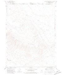
1973 Map of Star Valley Ridge East
USGS Topo · Published 1977About this map
Star Valley Ridge dominates this high-altitude landscape along the border of Nevada and Idaho, recorded during a 1973 field check. The terrain is defined by its remoteness and high elevation, where man-made infrastructure is limited to utility and transit corridors rather than permanent settlements. A Pipeline cuts across the southern elevations, running parallel to the drainage of Luke Creek in the southwest corner. The map provides an intricate view of the network of Jeep Trails and unnamed trails that navigate the ridges and canyons, reflecting a land used for resource management and backcountry access. This survey serves as a precise record of the administrative boundary between Owyhee and Elko counties, where the state line meets in a high-desert environment of steep contours and seasonal watercourses.
Find a feature on this map
7 named features on this map. Tap any name to fly to it.
Don’t see what you’re looking for? This feature index may not catch every label — zoom into the map to look around manually.
Map Details
Editions of this 1973 Star Valley Ridge East Map
This is the sole edition of this map. No revisions or reprints were ever made.
Other maps of this area

1955 · McDermitt
USGS Topo · 1:250,000

1955 · Jordan Valley
USGS Topo · 1:250,000

1957 · Jordan Valley
USGS Topo · 1:250,000

1958 · Jordan Valley
USGS Topo · 1:250,000

1959 · McDermitt
USGS Topo · 1:250,000

1973 · Coyote Hole
USGS Topo · 1:24,000

1973 · Bull Camp Butte
USGS Topo · 1:24,000

1973 · Star Valley Ridge SW
USGS Topo · 1:24,000
1973 · Star Valley
USGS Topo · 1:24,000
1973 · Rubber Hill
USGS Topo · 1:24,000