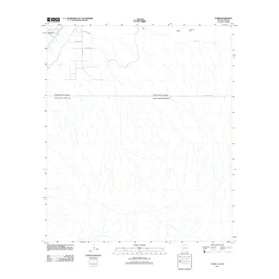
2011 Map of Stark
USGS Topo · Published 2011About this map
The San Pedro River cuts through the northwest corner of this arid borderlands landscape, where the international boundary between the United States and Mexico forms the dominant line across the terrain. Small settlements and local landmarks like Stark and the Valley View Ranch anchor the northern portion of the map, connected by a network of local roads with names like E Calle Venado and E Javelina Trl. Near the river, the Evelyn Field Airport provides a functional point of interest in a region otherwise characterized by broad ranchlands and drainage patterns. The stark layout of W International Rd tracing the southern edge highlights the proximity of the border in this part of Cochise County, while the S-O Ranch sits near the upper margin, illustrating the low-density pastoral use of the high desert floor.
Find a feature on this map
11 named features on this map. Tap any name to fly to it.
Don’t see what you’re looking for? This feature index may not catch every label — zoom into the map to look around manually.
Map Details
Editions of this 2011 Stark Map
This is the sole edition of this map. No revisions or reprints were ever made.
Other maps of this area

1902 · Bisbee
USGS Topo · 1:62,500

1910 · Bisbee
USGS Topo · 1:62,500

1914 · Hereford
USGS Topo · 1:125,000

1916 · Douglas
USGS Topo · 1:125,000

1919 · Douglas
USGS Topo · 1:125,000

1927 · Bisbee
USGS Topo · 1:62,500

1932 · Stark
USGS Topo · 1:62,500
1933 · Bisbee
USGS Topo · 1:62,500
1952 · Hereford
USGS Topo · 1:24,000
1952 · Nicksville
USGS Topo · 1:24,000