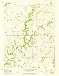
1973 Map of Stark
USGS Topo · Published 1975About this map
Stark and the surrounding prairie of Neosho and Allen counties appear here in the early 1970s, defined by a landscape where agriculture and the energy industry converge. The Missouri - Kansas - Texas railroad cuts a diagonal path through the southeastern townships, linking the rural communities of Kimball and Savonburg. This era shows a distributed network of social and religious centers, including Friends Home Ch, Evangelical Ch, and Bethel Ch, often situated near their respective family burial grounds like Putnam Cem. The drainage patterns of Canville Creek and Little Canville Creek dominate the central terrain, leading toward Timber Lake. Evidence of the region's mineral wealth is visible throughout the northwestern corner, where numerous Oil Wells and a designated Oil Field are interspersed with active Gas Wells, indicating the ongoing importance of petroleum extraction to the local economy alongside traditional farming.
Find a feature on this map
30 named features on this map. Tap any name to fly to it.
Don’t see what you’re looking for? This feature index may not catch every label — zoom into the map to look around manually.
Map Details
Editions of this 1973 Stark Map
This is the sole edition of this map. No revisions or reprints were ever made.
Other maps of this area

1886 · Iola
USGS Topo · 1:125,000

1893 · Iola
USGS Topo · 1:125,000

1904 · Iola
USGS Topo · 1:125,000

1947 · Joplin
USGS Topo · 1:250,000

1948 · Erie
USGS Topo · 1:62,500

1949 · Erie
USGS Topo · 1:62,500

1949 · Joplin
USGS Topo · 1:250,000
1951 · Chanute
USGS Topo · 1:62,500

1954 · Joplin
USGS Topo · 1:250,000

1958 · Joplin
USGS Topo · 1:250,000