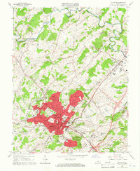
1964 Map of Staunton
USGS Topo · Published 1966About this map
Staunton is depicted here during a period of mid-century expansion, centered on its role as a regional hub for education, healthcare, and transit in the Shenandoah Valley. The urban core is densely developed, featuring prominent institutions such as Mary Baldwin College, the Staunton Military Academy, and the State School for Deaf and Blind. The intersection of the Chesapeake and Ohio and Chesapeake Western railroads underscores the city's historical dependency on rail commerce.
Find a feature on this map
63 named features on this map. Tap any name to fly to it.
Don’t see what you’re looking for? This feature index may not catch every label — zoom into the map to look around manually.
Map Details
Editions of this 1964 Staunton Map
4 editions found
Other maps of this area

1892 · Harrisonburg
USGS Topo · 1:125,000

1894 · Staunton
USGS Topo · 1:125,000

1934 · Waynesboro
USGS Topo · 1:48,000

1939 · Waynesboro
USGS Topo · 1:62,500

1941 · Harrisonburg
USGS Topo · 1:62,500

1943 · Harrisonburg
USGS Topo · 1:62,500

1944 · Parnassus
USGS Topo · 1:62,500

1944 · Staunton
USGS Topo · 1:62,500

1947 · Staunton
USGS Topo · 1:62,500

1947 · Parnassus
USGS Topo · 1:62,500