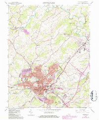
1964 Map of Staunton
USGS Topo · Published 1986About this map
The independent city of Staunton serves as a dense institutional and educational hub in the heart of Augusta County, as shown in this mid-century survey with revisions through the 1980s. The landscape is defined by its significant civic landmarks, including the historic Mary Baldwin College, the Virginia State School for Deaf and Blind, and the Woodrow Wilson Birthplace. Outside the urban center, the terrain is marked by the twin peaks of Betsey Bell and Mary Gray, while the Middle River meanders to the north, passing old industrial sites like Franks Mill and Quicks Mill.
Find a feature on this map
61 named features on this map. Tap any name to fly to it.
Don’t see what you’re looking for? This feature index may not catch every label — zoom into the map to look around manually.
Map Details
Editions of this 1964 Staunton Map
4 editions found
Other maps of this area

1892 · Harrisonburg
USGS Topo · 1:125,000

1894 · Staunton
USGS Topo · 1:125,000

1934 · Waynesboro
USGS Topo · 1:48,000

1939 · Waynesboro
USGS Topo · 1:62,500

1941 · Harrisonburg
USGS Topo · 1:62,500

1943 · Harrisonburg
USGS Topo · 1:62,500

1944 · Parnassus
USGS Topo · 1:62,500

1944 · Staunton
USGS Topo · 1:62,500

1947 · Staunton
USGS Topo · 1:62,500

1947 · Parnassus
USGS Topo · 1:62,500