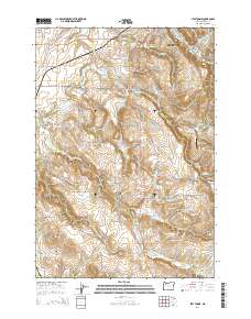
2014 Map of Stayton NE
USGS Topo · Published 2014About this map
The city of Silverton serves as the gateway to the fertile agricultural lands and undulating terrain of Marion County. The landscape is defined by a dense network of water management features, including Bye Reservoir, Urban Reservoir, and Kuenzi Reservoir, which support the region's productive farms. The Pudding River and its tributary, the S Fork Pudding River, meander through the western and southern reaches, while the Waldo Hills rise to the south. Local history and genealogy are well-represented by several family and community burial sites, such as the Kimsey Walker Cem, Mt Hope Cem, and Pratum Cem. Transportation across the rural landscape is anchored by the Iron Crown Airport and the prominent corridor of Cascade Hwy NE, connecting the small settlement of Howell Prairie to the broader Willamette Valley.
Find a feature on this map
84 named features on this map. Tap any name to fly to it.
Don’t see what you’re looking for? This feature index may not catch every label — zoom into the map to look around manually.
Map Details
Editions of this 2014 Stayton NE Map
This is the sole edition of this map. No revisions or reprints were ever made.
Other maps of this area

1923 · Mount Angel
USGS Topo · 1:62,500

1925 · Stayton
USGS Topo · 1:62,500

1939 · Molalla
USGS Topo · 1:62,500

1940 · Molalla
USGS Topo · 1:62,500

1940 · Mount Angel
USGS Topo · 1:62,500

1941 · Stayton
USGS Topo · 1:62,500

1948 · Vancouver
USGS Topo · 1:250,000

1950 · Vancouver
USGS Topo · 1:250,000

1950 · Vancouver
USGS Topo · 1:250,000

1951 · Lyons
USGS Topo · 1:62,500