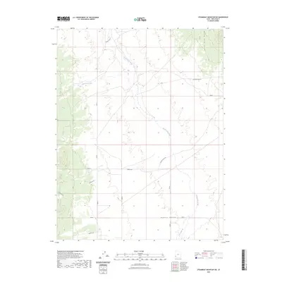
2023 Map of Steamboat Mountain SW
USGS Topo · Published 2023About this map
Hamlin Valley defines this arid landscape along the western edge of Iron County, where high-altitude desert basins meet the foothills of the Indian Peak Range. The topography is dominated by the broad, south-trending Hamlin Valley Wash, which collects runoff from seasonal drainages like Chokecherry Creek and Pine Creek. This 2023 survey illustrates the sparse, high-desert infrastructure of the region, anchored by the State Line Bench near the Nevada border. Local travel is facilitated by ranching and resource-access tracks such as R R Ranch Rd and Arrowhead Mine Rd, reflecting the area's ongoing use for grazing and mining. The geography of the Upper Basin remains largely open, with isolated landmarks like Hamlin Basin S Spr providing critical water points in an otherwise thirsty terrain.
Find a feature on this map
11 named features on this map. Tap any name to fly to it.
Don’t see what you’re looking for? This feature index may not catch every label — zoom into the map to look around manually.
Map Details
Editions of this 2023 Steamboat Mountain SW Map
This is the sole edition of this map. No revisions or reprints were ever made.
Other maps of this area

1885 · St. George
USGS Topo · 1:250,000

1885 · Pioche
USGS Topo · 1:250,000

1886 · Pioche
USGS Topo · 1:250,000

1891 · St. George
USGS Topo · 1:250,000

1953 · Richfield
USGS Topo · 1:250,000

1953 · Cedar City
USGS Topo · 1:250,000

1954 · Caliente
USGS Topo · 1:250,000

1956 · Lund
USGS Topo · 1:250,000

1958 · Richfield
USGS Topo · 1:250,000

1958 · Cedar City
USGS Topo · 1:250,000