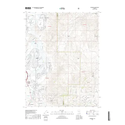
2018 Map of Steamboat
USGS Topo · Published 2018About this map
Reno and its southeastern neighborhoods define this modern landscape, where the urban edge of the Truckee Meadows meets the high desert terrain of the Virginia Range. This detailed topographical view records the significant hydrography of the region, anchored by Steamboat Creek and a network of thermal and freshwater features including Steamboat Springs, Reno Hot Springs, and Huffaker Springs. The map illustrates the sophisticated irrigation and water management systems necessary for this arid environment, featuring the Crane Ditch, Chandler Ditch, and Boynton Slough. To the south, the settlement of Steamboat sits near the base of the mountains, while the northeastern quadrant is occupied by the established community of Hidden Valley. Elevation changes are marked by prominent landmarks such as Castle Peak and Washington Hill, while the western margin includes a portion of the Toiyabe National Forest, showing the proximity of protected federal lands to the expanding residential developments.
Find a feature on this map
102 named features on this map. Tap any name to fly to it.
Don’t see what you’re looking for? This feature index may not catch every label — zoom into the map to look around manually.
Map Details
Editions of this 2018 Steamboat Map
This is the sole edition of this map. No revisions or reprints were ever made.
Other maps of this area

1891 · Carson
USGS Topo · 1:125,000

1891 · Reno
USGS Topo · 1:125,000

1893 · Carson
USGS Topo · 1:125,000

1893 · Reno
USGS Topo · 1:125,000

1950 · Virginia City
USGS Topo · 1:62,500

1950 · Mt. Rose
USGS Topo · 1:62,500

1950 · Reno
USGS Topo · 1:62,500

1951 · Reno
USGS Topo · 1:62,500

1952 · Mt. Rose
USGS Topo · 1:62,500

1952 · Virginia City
USGS Topo · 1:62,500