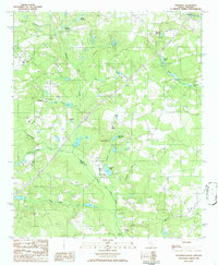
1986 Map of Steedman
USGS Topo · Published 1986About this map
Steedman and Samaria serve as the primary focal points of this mid-1980s landscape at the border of Lexington Co and Aiken Co. The topography is defined by an intricate network of waterways draining toward the North Fork Edisto River in the south, including Goose Platter Creek and Carneys Creek. This region is notable for its numerous family-named millponds and water bodies, such as Brodie Millpond, Abells Millpond, and Hallman Millpond, which suggest a long history of local water management and small-scale industry. The presence of Camp Clark and several unnamed cemeteries scattered throughout the rural sections provides valuable points of interest for local historians and genealogists. Infrastructure of the era is marked by a prominent Pipeline and Gas Pipeline corridor cutting across the terrain, illustrating the modern utility expansion into this traditional agricultural and wooded landscape.
Find a feature on this map
30 named features on this map. Tap any name to fly to it.
Don’t see what you’re looking for? This feature index may not catch every label — zoom into the map to look around manually.
Map Details
Editions of this 1986 Steedman Map
This is the sole edition of this map. No revisions or reprints were ever made.
Other maps of this area

1920 · Aiken
USGS Topo · 1:48,000

1921 · Aiken
USGS Topo · 1:62,500

1943 · Aiken
USGS Topo · 1:62,500

1944 · Gilbert
USGS Topo · 1:62,500

1944 · Seivern
USGS Topo · 1:62,500

1954 · Augusta
USGS Topo · 1:250,000

1957 · Augusta
USGS Topo · 1:250,000

1958 · Augusta
USGS Topo · 1:250,000

1961 · Augusta
USGS Topo · 1:250,000

1962 · Augusta
USGS Topo · 1:250,000