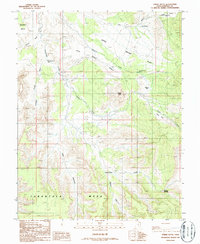
1986 Map of Steele Butte
USGS Topo · Published 1987About this map
Steele Bench and Tarantula Mesa dominate this high-altitude landscape in Garfield County, recorded in this 1986 provisional survey. The map reveals a terrain defined by stark flat-topped mesas and deep seasonal drainages, including the dramatic incisions of Five Canyon and Seven Canyon. Water sources are critical but sparse markers in this arid environment, noted by Dripping Rock Seep, Dave Teeples Spring, and Mud Spring. Evidence of human activity is minimal but specific, featuring a Landing Strip on Pete Steele Bench and a lonely Adit tucked near Sweetwater Creek. The topographical detail traces the complex network of washes like Poison Wash and Dry Wash as they carve through the Apple Brush Flat, providing a clear record of the area's remote character during the mid-1980s.
Find a feature on this map
23 named features on this map. Tap any name to fly to it.
Don’t see what you’re looking for? This feature index may not catch every label — zoom into the map to look around manually.
Map Details
Editions of this 1986 Steele Butte Map
This is the sole edition of this map. No revisions or reprints were ever made.
Other maps of this area

1885 · San Rafael
USGS Topo · 1:250,000

1885 · Fish Lake
USGS Topo · 1:250,000

1886 · Escalante
USGS Topo · 1:250,000

1886 · Henry Mountains
USGS Topo · 1:250,000

1892 · Henry Mountains
USGS Topo · 1:250,000

1896 · Fish Lake
USGS Topo · 1:250,000

1952 · Notom 4 SE
USGS Topo · 1:24,000

1952 · Mt Pennell 2 NE
USGS Topo · 1:24,000

1952 · Notom 4 NE
USGS Topo · 1:24,000

1952 · Notom
USGS Topo · 1:62,500