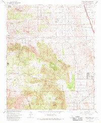
1967 Map of Steele Peak
USGS Topo · Published 1969About this map
March Air Force Base dominates the northeastern corner of this Riverside County landscape, providing a sharp contrast to the surrounding agricultural and mining terrain. The map details a transition from organized military infrastructure and the residential grid of Perris and Val Verde into the rugged elevations of the Gavilan Plateau and Steele Peak. The presence of the Colorado River Aqueduquct cutting across the central hills highlights the critical water management systems required to sustain growth in this part of Southern California.
Find a feature on this map
47 named features on this map. Tap any name to fly to it.
Don’t see what you’re looking for? This feature index may not catch every label — zoom into the map to look around manually.
Map Details
Editions of this 1967 Steele Peak Map
3 editions found
Other maps of this area

1901 · Southern California Sheet No. 1
USGS Topo · 1:250,000

1901 · Elsinore
USGS Topo · 1:125,000

1901 · Riverside
USGS Topo · 1:62,500

1904 · Southern California Sheet No. 1
USGS Topo · 1:250,000

1942 · Lake Elsinore
USGS Topo · 1:62,500
1942 · Riverside and Vicinity
USGS Topo · 1:31,680

1942 · Murrieta
USGS Topo · 1:62,500

1942 · Riverside
USGS Topo · 1:62,500

1942 · Perris
USGS Topo · 1:62,500

1943 · Perris
USGS Topo · 1:62,500