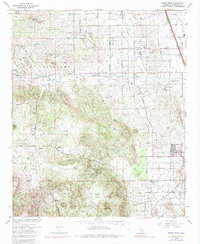
1967 Map of Steele Peak
USGS Topo · Published 1987About this map
March Air Force Base occupies the northeastern corner of this Riverside County landscape, establishing a military presence on the edge of the sprawling Mead Valley. The agricultural and ranching character of the 1960s is evident through the network of wells and water tanks servicing settlements like Glen Valley and Val Verde. Heavy infrastructure cuts across the terrain, notably the Colorado River Aqueduct and the Atchison Topeka and Santa Fe railroad, which includes the Granite Spur near the developing town of Perris.
Find a feature on this map
43 named features on this map. Tap any name to fly to it.
Don’t see what you’re looking for? This feature index may not catch every label — zoom into the map to look around manually.
Map Details
Editions of this 1967 Steele Peak Map
3 editions found
Other maps of this area

1901 · Southern California Sheet No. 1
USGS Topo · 1:250,000

1901 · Elsinore
USGS Topo · 1:125,000

1901 · Riverside
USGS Topo · 1:62,500

1904 · Southern California Sheet No. 1
USGS Topo · 1:250,000

1942 · Lake Elsinore
USGS Topo · 1:62,500
1942 · Riverside and Vicinity
USGS Topo · 1:31,680

1942 · Murrieta
USGS Topo · 1:62,500

1942 · Riverside
USGS Topo · 1:62,500

1942 · Perris
USGS Topo · 1:62,500

1943 · Perris
USGS Topo · 1:62,500