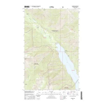
2017 Map of Stehekin
USGS Topo · Published 2017About this map
The Stehekin River flows southeast through a narrow valley before emptying into the northern tip of Lake Chelan, a landscape defined by the convergence of the Lake Chelan National Recreation Area and the Wenatchee National Forest. This 2017 survey details the remote settlement of Stehekin, situated near Purple Point, and the upstream enclave of McGregor Meadows. Access is anchored by the Stehekin State Airport and the Stehekin Valley Rd, the primary corridor linking the valley's scattered private land blocks. Notable landmarks such as Rainbow Falls and the Painted Rocks along the shoreline illustrate the geographic character of this roadless-access community. High-elevation features like Rainbow Mtn and the Fourth of July Basin dominate the surrounding terrain, while various drainage systems including Devore Creek and Company Creek feed into the central river system.
Find a feature on this map
91 named features on this map. Tap any name to fly to it.
Don’t see what you’re looking for? This feature index may not catch every label — zoom into the map to look around manually.
Map Details
Editions of this 2017 Stehekin Map
This is the sole edition of this map. No revisions or reprints were ever made.
Other maps of this area

1902 · Stehekin
USGS Topo · 1:125,000

1904 · Stehekin
USGS Topo · 1:125,000

1944 · Holden
USGS Topo · 1:62,500

1944 · Lucerne
USGS Topo · 1:62,500

1949 · Lucerne
USGS Topo · 1:62,500

1949 · Holden
USGS Topo · 1:62,500

1955 · Concrete
USGS Topo · 1:250,000

1958 · Concrete
USGS Topo · 1:250,000

1962 · Concrete
USGS Topo · 1:250,000

1963 · Mc Gregor Mtn
USGS Topo · 1:24,000