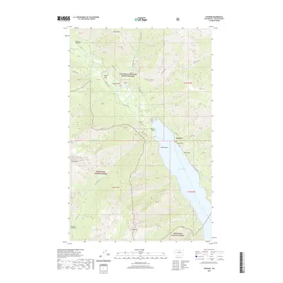
2020 Map of Stehekin
USGS Topo · Published 2020About this map
Lake Chelan anchors the southeastern corner of this map, serving as the gateway to the remote settlement of Stehekin. The community and its small Stehekin State Airport are positioned at the head of the lake, where the glacial waters of the Stehekin River terminate. This 2020 survey reveals a landscape largely managed by the Lake Chelan National Recreation Area and the Wenatchee National Forest, where steep drainages like Rainbow Creek and Devore Creek feed the main valley. Notable landmarks such as Painted Rocks and Purple Point line the lakeshore, while high-altitude features like Tupshin Peak and the Fourth of July Basin define the surrounding heights. The map traces the essential transportation corridors of this roadless region, including the Rainbow Loop and Imus Loop trails, which connect the valley floor to spectacular features like Rainbow Falls.
Find a feature on this map
61 named features on this map. Tap any name to fly to it.
Don’t see what you’re looking for? This feature index may not catch every label — zoom into the map to look around manually.
Map Details
Editions of this 2020 Stehekin Map
This is the sole edition of this map. No revisions or reprints were ever made.
Other maps of this area

1902 · Stehekin
USGS Topo · 1:125,000

1904 · Stehekin
USGS Topo · 1:125,000

1944 · Holden
USGS Topo · 1:62,500

1944 · Lucerne
USGS Topo · 1:62,500

1949 · Lucerne
USGS Topo · 1:62,500

1949 · Holden
USGS Topo · 1:62,500

1955 · Concrete
USGS Topo · 1:250,000

1958 · Concrete
USGS Topo · 1:250,000

1962 · Concrete
USGS Topo · 1:250,000

1963 · Mc Gregor Mtn
USGS Topo · 1:24,000