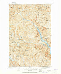
1902 Map of Stehekin
USGS Topo · Published 1965About this map
Lake Chelan anchors this turn-of-the-century survey, its northern waters reaching toward the isolated outpost of Stehekin. The map documents a landscape defined by dramatic elevation changes, from the lake shore up to high-altitude landmarks like Bonanza Peak and the Lyman Glacier. The presence of the Holden Railroad near Lucerne and Refrigerator Harbor hints at the industrial and logistical efforts required to extract resources from these high mountains, while the settlement of Gilbert sits at the head of the Twisp River drainage.
Find a feature on this map
115 named features on this map. Tap any name to fly to it.
Don’t see what you’re looking for? This feature index may not catch every label — zoom into the map to look around manually.
Map Details
Editions of this 1902 Stehekin Map
2 editions found
Other maps of this area

1899 · Glacier Peak
USGS Topo · 1:125,000

1899 · Methow
USGS Topo · 1:125,000

1901 · Glacier Peak
USGS Topo · 1:125,000

1901 · Chelan
USGS Topo · 1:125,000

1901 · Methow
USGS Topo · 1:125,000

1901 · Chiwaukum
USGS Topo · 1:125,000

1902 · Skykomish
USGS Topo · 1:125,000

1902 · Stehekin
USGS Topo · 1:125,000

1904 · Stehekin
USGS Topo · 1:125,000

1904 · Chiwaukum
USGS Topo · 1:125,000