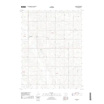
2017 Map of Steinauer
USGS Topo · Published 2017About this map
Steinauer serves as the primary hub for this rural corner of Pawnee County, where the village grid centers on Josephine St and 4th St. The surrounding countryside is defined by a dense network of watercourses, including Turkey Creek and Rock Creek, which cut through the agricultural landscape. Local history is anchored by several burial grounds, most notably Saint Anthonys Cem located just east of the village, along with the more remote Beranek Cem and Clear Creek Cem.
Find a feature on this map
47 named features on this map. Tap any name to fly to it.
Don’t see what you’re looking for? This feature index may not catch every label — zoom into the map to look around manually.
Map Details
Editions of this 2017 Steinauer Map
This is the sole edition of this map. No revisions or reprints were ever made.
Other maps of this area

1955 · Lincoln
USGS Topo · 1:250,000

1957 · Lincoln
USGS Topo · 1:250,000

1958 · Lincoln
USGS Topo · 1:250,000

1965 · Pawnee City
USGS Topo · 1:24,000

1965 · Burchard
USGS Topo · 1:24,000

1965 · Table Rock
USGS Topo · 1:24,000

1965 · Tecumseh
USGS Topo · 1:24,000
1965 · Steinauer
USGS Topo · 1:24,000
1965 · Tecumseh SE
USGS Topo · 1:24,000
1965 · Du Bois
USGS Topo · 1:24,000