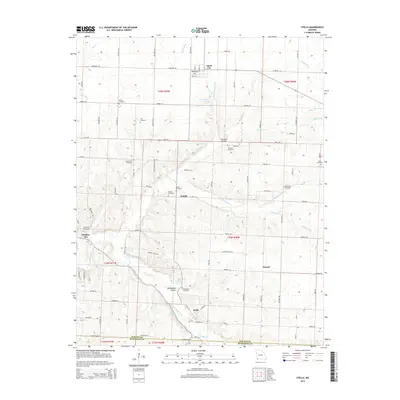
2015 Map of Stella
USGS Topo · Published 2015About this map
Stark City and the southern settlement of Stella anchor this landscape along the border of Newton County and McDonald County. The terrain is defined by a dense network of tributaries including Middle Indian Cr, South Indian Creek, and Stedman Br that carve through hollows like Shannon Hollow and Edmondson Hollow. For genealogists and local historians, the sheet is particularly dense with rural burial grounds, ranging from the Hazelgreen Cemetery near Boulder City to the Dice Cemetery on the eastern edge. This distribution of sites like Macedonia Cemetery and Ivie Cemetery suggests a well-established pattern of small farming communities and family settlements that persisted into the early 21st century. Natural springs, including Macedonia Spring and Lentz Spring, continue to mark the hydrological character of this corner of southwest Missouri.
Find a feature on this map
80 named features on this map. Tap any name to fly to it.
Don’t see what you’re looking for? This feature index may not catch every label — zoom into the map to look around manually.
Map Details
Editions of this 2015 Stella Map
This is the sole edition of this map. No revisions or reprints were ever made.
Other maps of this area

1916 · Neosho
USGS Topo · 1:62,500

1940 · Noel
USGS Topo · 1:62,500

1941 · Rocky Comfort
USGS Topo · 1:62,500

1943 · Ritchey
USGS Topo · 1:62,500

1943 · Noel
USGS Topo · 1:62,500

1943 · Rocky Comfort
USGS Topo · 1:62,500

1954 · Tulsa
USGS Topo · 1:250,000

1958 · Tulsa
USGS Topo · 1:250,000

1963 · Tulsa
USGS Topo · 1:250,000
1972 · Granby
USGS Topo · 1:24,000