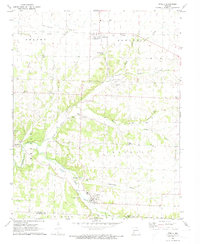
1972 Map of Stella
USGS Topo · Published 1974About this map
Olivers Prairie and the surrounding hills of southwestern Missouri are defined by a complex network of spring-fed waterways, including North Indian Creek and Middle Indian Creek. The cultural landscape of the early 1970s reveals a pattern of dispersed rural settlements like Stark City, Wanda, and Stella, connected by an older infrastructure evidenced by the Old Railroad Grade traversing the northern townships.
Find a feature on this map
43 named features on this map. Tap any name to fly to it.
Don’t see what you’re looking for? This feature index may not catch every label — zoom into the map to look around manually.
Map Details
Editions of this 1972 Stella Map
This is the sole edition of this map. No revisions or reprints were ever made.
Other maps of this area

1916 · Neosho
USGS Topo · 1:62,500

1940 · Noel
USGS Topo · 1:62,500

1941 · Rocky Comfort
USGS Topo · 1:62,500

1943 · Ritchey
USGS Topo · 1:62,500

1943 · Noel
USGS Topo · 1:62,500

1943 · Rocky Comfort
USGS Topo · 1:62,500

1954 · Tulsa
USGS Topo · 1:250,000

1958 · Tulsa
USGS Topo · 1:250,000

1963 · Tulsa
USGS Topo · 1:250,000
1972 · Granby
USGS Topo · 1:24,000