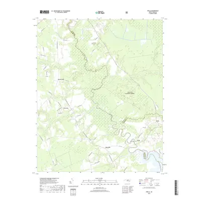
2019 Map of Stella
USGS Topo · Published 2019About this map
The White Oak River serves as the winding centerpiece for this coastal Carolina landscape, defining the boundaries where Onslow, Jones, and Carteret counties meet. The river’s serpentine path is mirrored by a complex network of tributaries such as Hunters Creek and Grants Creek, carving through the dense pine and swamp lands of the Croatan National Forest. Small rural crossroads and communities like Silverdale and Stella are connected by historical routes including the Belgrade Swansboro Rd and Stella Rd, which lead to the Stella Bridge crossing. The terrain is a mosaic of low-lying wetlands and established family-named roads, from Pala Alto to Morton Fork, revealing a settlement pattern deeply influenced by the tidal waters and agricultural reaches of the eastern seaboard.
Find a feature on this map
60 named features on this map. Tap any name to fly to it.
Don’t see what you’re looking for? This feature index may not catch every label — zoom into the map to look around manually.
Map Details
Editions of this 2019 Stella Map
This is the sole edition of this map. No revisions or reprints were ever made.
Other maps of this area

1942 · Maysville
USGS Topo · 1:62,500

1942 · Swansboro
USGS Topo · 1:62,500

1943 · Jacksonville
USGS Topo · 1:62,500

1948 · Maysville
USGS Topo · 1:62,500

1948 · Swansboro
USGS Topo · 1:62,500

1948 · New River
USGS Topo · 1:62,500

1952 · Hubert
USGS Topo · 1:24,000

1952 · Camp Lejeune
USGS Topo · 1:24,000

1952 · Swansboro
USGS Topo · 1:24,000

1953 · Beaufort
USGS Topo · 1:250,000