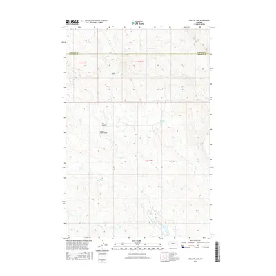
2017 Map of Stellar Lake
USGS Topo · Published 2017About this map
Stellar Lake and the surrounding drainage of Little Porcupine Cr characterize this portion of Rosebud County. The terrain is marked by a complex system of seasonal watercourses and landforms, including Russian Frank Coulee and Hoff Coulee, which shape the local ranching and grazing landscape. The northern portion of the map is defined by the east-west boundary between Garfield County and Rosebud County, illustrating the jurisdictional divisions within this sparsely settled part of Montana.
Find a feature on this map
9 named features on this map. Tap any name to fly to it.
Don’t see what you’re looking for? This feature index may not catch every label — zoom into the map to look around manually.
Map Details
Editions of this 2017 Stellar Lake Map
This is the sole edition of this map. No revisions or reprints were ever made.
Other maps of this area

1954 · Forsyth
USGS Topo · 1:250,000

1957 · Forsyth
USGS Topo · 1:250,000

1958 · Forsyth
USGS Topo · 1:250,000

1965 · Black Hills
USGS Topo · 1:24,000

1965 · Needle Butte Reservoir
USGS Topo · 1:24,000
1965 · Mother Butte
USGS Topo · 1:24,000
1965 · Antelope Springs
USGS Topo · 1:24,000

1965 · Vanstel
USGS Topo · 1:24,000

1965 · Stellar Lake
USGS Topo · 1:24,000

1969 · Rudie Coulee
USGS Topo · 1:24,000