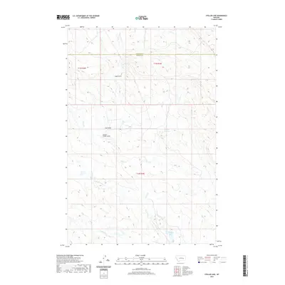
2020 Map of Stellar Lake
USGS Topo · Published 2020About this map
Stellar Lake and the surrounding drainage systems of southern Garfield and Rosebud Counties define this high-plains landscape. The area is characterized by intermittent watercourses and land management features like the Wagner Reservoir, which support agricultural activity in a semi-arid region. Named coulees such as Russian Frank Coulee and Hoff Coulee cut through the terrain, suggesting a history of local land use and grazing. The complex network of seasonal creeks, including Little Porcupine Creek, Cherry Creek, and Coyote Creek, illustrates the natural watershed patterns of the Montana prairie. Landform labels like Engine Draw further specify the local topography, providing a detailed look at the drainage basins that transition between the two counties.
Find a feature on this map
12 named features on this map. Tap any name to fly to it.
Don’t see what you’re looking for? This feature index may not catch every label — zoom into the map to look around manually.
Map Details
Editions of this 2020 Stellar Lake Map
This is the sole edition of this map. No revisions or reprints were ever made.
Other maps of this area

1954 · Forsyth
USGS Topo · 1:250,000

1957 · Forsyth
USGS Topo · 1:250,000

1958 · Forsyth
USGS Topo · 1:250,000

1965 · Black Hills
USGS Topo · 1:24,000

1965 · Needle Butte Reservoir
USGS Topo · 1:24,000
1965 · Mother Butte
USGS Topo · 1:24,000
1965 · Antelope Springs
USGS Topo · 1:24,000

1965 · Vanstel
USGS Topo · 1:24,000

1965 · Stellar Lake
USGS Topo · 1:24,000

1969 · Rudie Coulee
USGS Topo · 1:24,000