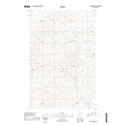
2020 Map of Stensgar Mountain
USGS Topo · Published 2020About this map
Stensgar Mountain and the surrounding high country of the Huckleberry Range dominate this Stevens County landscape. This 2020 topographic record highlights a region defined by complex drainage networks, where the headwaters of Huckleberry Creek and Deer Creek carve through steep terrain. The map identifies specific high-elevation clearings and small settlements like Klein Meadows and Miller Meadow, which likely reflect the area's grazing or homesteading history. Pockets of activity are concentrated along routes like Red Marble Road, while the western reaches are defined by the deep profile of Blackhorse Canyon. The drainage patterns, including S Fork Harvey Creek and Waits Creek, illustrate the watershed's significance to the larger Columbia River basin, providing a detailed view of the land as it exists in the early 21st century.
Find a feature on this map
31 named features on this map. Tap any name to fly to it.
Don’t see what you’re looking for? This feature index may not catch every label — zoom into the map to look around manually.
Map Details
Editions of this 2020 Stensgar Mountain Map
This is the sole edition of this map. No revisions or reprints were ever made.
Other maps of this area

1927 · Chewelah
USGS Topo · 1:125,000

1930 · Chewelah
USGS Topo · 1:125,000

1948 · Hunters
USGS Topo · 1:62,500

1950 · Hunters
USGS Topo · 1:62,500

1950 · Inchelium
USGS Topo · 1:62,500

1954 · Okanogan
USGS Topo · 1:250,000

1958 · Okanogan
USGS Topo · 1:250,000

1958 · Sandpoint
USGS Topo · 1:250,000

1963 · Sandpoint
USGS Topo · 1:250,000
1965 · Empey Mountain
USGS Topo · 1:24,000