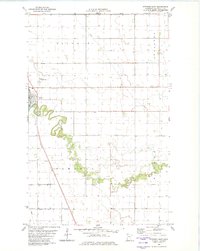
1982 Map of Stephen East
USGS Topo · Published 1982About this map
The Tamarac River meanders sharply through the Red River Valley in this early 1980s landscape, defining the character of the northwestern Minnesota prairie. The town of Stephen serves as the regional hub, situated where the Burlington Northern railroad corridor meets local road networks. The influence of agricultural engineering is evident in the structured drainage systems of County Ditch No 18 and Jud Ditch No 29, which crisscross the surrounding townships of Sinnott, Augsburg, Tamarac, and Wanger. Local community landmarks include St Stephen Cem and Wayside Park, while the Stephen Municipal Airport and the railroad indicate the area's role as a transportation and shipping node for the surrounding farmland.
Find a feature on this map
15 named features on this map. Tap any name to fly to it.
Don’t see what you’re looking for? This feature index may not catch every label — zoom into the map to look around manually.
Map Details
Editions of this 1982 Stephen East Map
This is the sole edition of this map. No revisions or reprints were ever made.
Other maps of this area

1918 · Argyle
USGS Topo · 1:62,500

1939 · Kennedy
USGS Topo · 1:62,500

1941 · Kennedy
USGS Topo · 1:62,500

1952 · Thief River Falls
USGS Topo · 1:250,000

1954 · Stephen
USGS Topo · 1:62,500

1956 · Thief River Falls
USGS Topo · 1:250,000

1956 · Karlstad
USGS Topo · 1:62,500

1956 · Florian
USGS Topo · 1:62,500

1957 · Thief River Falls
USGS Topo · 1:250,000

1967 · Thief River Falls
USGS Topo · 1:250,000