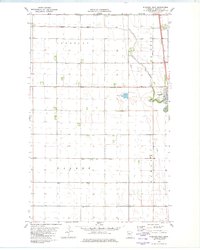
1982 Map of Stephen West
USGS Topo · Published 1982About this map
The Tamarac River winds through the Red River Valley, defining the landscape of Marshall County in the early 1980s. This western portion of Stephen shows a community organized around the Burlington Northern railroad corridor, which runs parallel to U.S. Highway 75. The topography is exceptionally flat, shaped by a dense network of water management features including Judicial Ditch No 9, County Ditch No 12, and Lateral No 1. These man-made channels highlight the region's agricultural dependency on sophisticated drainage systems to manage the fertile but low-lying plains. Beyond the town center, landmarks such as a Radio Tower, a Golf Course, and the Sewage Disposal Ponds provide clear points of reference for local history research and land use studies in Donnelly, Sinnott, and Parker townships.
Find a feature on this map
16 named features on this map. Tap any name to fly to it.
Don’t see what you’re looking for? This feature index may not catch every label — zoom into the map to look around manually.
Map Details
Editions of this 1982 Stephen West Map
This is the sole edition of this map. No revisions or reprints were ever made.
Other maps of this area

1918 · Acton
USGS Topo · 1:62,500

1918 · Argyle
USGS Topo · 1:62,500

1939 · Drayton
USGS Topo · 1:62,500

1939 · Kennedy
USGS Topo · 1:62,500

1941 · Kennedy
USGS Topo · 1:62,500

1941 · Drayton
USGS Topo · 1:62,500

1952 · Thief River Falls
USGS Topo · 1:250,000

1954 · Stephen
USGS Topo · 1:62,500

1956 · Thief River Falls
USGS Topo · 1:250,000

1957 · Thief River Falls
USGS Topo · 1:250,000