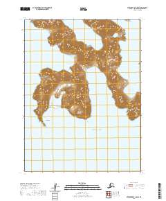
2020 Map of Stepovak Bay A-5 SW
USGS Topo · Published 2020About this map
Kuniguigan defines the shoreline along the southwestern peninsula of this Aleutian landscape, where high ridgelines drop steeply into the surrounding waters. The topography here is characterized by dramatic elevation changes, with peaks rising directly from the coast to overlook Yukon Harbor to the east and the open Pacific Ocean to the south. This 2020 survey records the intricate coastal geometry of the Alaska Peninsula, where narrow inlets and harbors provided natural shelters along an otherwise exposed maritime corridor. The map's detail focuses on the physical geography and hydrography of the region, emphasizing the relationship between the mountainous interior and the tidal zones of the northern Pacific, reflecting a landscape shaped by geological forces and the sea.
Find a feature on this map
8 named features on this map. Tap any name to fly to it.
Don’t see what you’re looking for? This feature index may not catch every label — zoom into the map to look around manually.
Map Details
Editions of this 2020 Stepovak Bay A-5 SW Map
This is the sole edition of this map. No revisions or reprints were ever made.
Other maps of this area

1951 · Stepovak Bay
USGS Topo · 1:250,000
1963 · Simeonof Island D-2
USGS Topo · 1:63,360
1963 · Simeonof Island D-3
USGS Topo · 1:63,360
1963 · Stepovak Bay A-6
USGS Topo · 1:63,360
1963 · Stepovak Bay A-5
USGS Topo · 1:63,360

1963 · Simeonof Island
USGS Topo · 1:250,000

1963 · Stepovak Bay
USGS Topo · 1:250,000

1967 · Simeonof Island
USGS Topo · 1:250,000

1969 · Stepovak Bay
USGS Topo · 1:250,000
2020 · Simeonof Island D-2 NE
USGS Topo · 1:25,000